Continued from page 2.
Township. In 1872, the separate
townships of Hayes, Iowa, and Nishnabotny (note the
correct spelling is Nishnabotna) were created, although Nishnabotny
and Iowa were still both attached to Washington Township for judicial and
financial purposes. They finally became independent in 1873, and the first
elections were held at the Hilsabeck Schoolhouse (Iowa Township) and John
Theobald Schoolhouse (Nishnabotny Township).
Much of the land in this area was "swamp land,"
and transferred from the United States, to the State of Iowa, to Marshall
County (which included much of west central Iowa at the time), and finally to
landowners for $1.25 an acre or less. Iowa Township contained 5,722.28 acres of
swamp land, according to the 1853 Act of Iowa. But even though the land was
cheap, there were few takers, as our part of the county had little to offer in
the lines of transportation, fuel or shelter. In 1862, Crawford County agreed
to give all remaining unsold swamp lands in the county to the American Emigrant
Company, who could sell the lands for $1.25 an acre or more, and who in return
would have to make any public improvements ordered by
the county not exceeding $200 in costs. The agreement was approved in a special
election by a 17 to 9 vote, and the terms were to be in effect for four years.
As the railroad advanced west from the Mississippi River,
railroad officials often sought certain favors to help them decide where the
lines should be planned. Crawford County was asked to give up its remaining
swamp lands, in return for a promise that the railroad reached the town of
Denison or within five miles of Denison by 1869; the vote taken in 1866 was 41 in favor of the plan. The railroad
apparently agreed to work with the American Emigrant Land Company, as the two
firms still held title to more than 11,000 acres of land in Crawford County in 1869.
The railroad reached Denison in 1866, and the population of
the county doubled within two years, from 574 in 1865 to 1,100 in 1867.
Although the main reason for the population explosion was the easier, cheaper
way of transporting people, merchandise, and farm products, the end of the
Civil War in 1865 also played a big role. Nearly all able-bodied men had been
involved in the war, and they were now returning home; newcomers who were ready
to exchange the adversities of war for the adversities of the frontier also arrived.
Train loads of prospective land buyers poured into the
county in the late 1860s and throughout the 1870s. The NorthWestern,
which crossed Crawford County, competed with three other rail lines which
crossed Iowa by offering free rides to anyone who bought 160 acres of more land
along their route; the railroad ride was half-price to anyone who bought less than 160 acres.
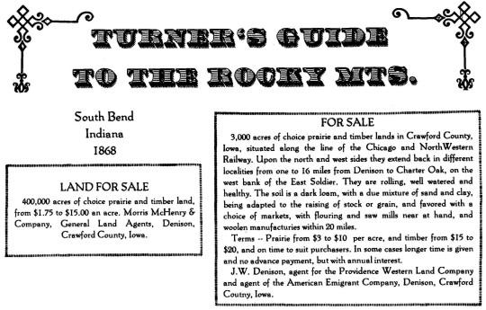
Vividly worded advertising books, such as Turner's Guide to the Rocky Mountains,
helped entice new land owners. Ads for Crawford County were placed by private
land agents such as Morris and W.A. McHenry, who sold land for the American
Emigrant Company, the Rock Island and Pacific Land Company, the Blair Town Lot
and Land Company, the Iowa Railroad Company, and the Providence Western Land Company.
Land was also sold by development firms, such as the
Providence, Rhode Island, investors who started their Western Land Company by
obtaining 20,000 acres of land in Crawford and Harrison Counties from veterans
of the wars of 1812 and with Mexico. These veterans could claim 160 acres of
unoccupied land in the western states, to either keep or sell; the Providence
Western Land Company encouraged a number of the soldiers to file on land in a
group, and the company then purchased the land for around 60c an acre. The land
agent in this area was J.W. Denison, who had created, named, and sold lots in
the company's new town of Denison. The town was formed in 1856; by 1873, land
around Denison was selling for $40 to $50 an acre, although "wild
lands" a distance from town could still be purchased for around $5 an acre.
The railroads also had real estate subsidiaries like the
Iowa Land Company and the Emigrant Land Company which sold land owned by the
railroads. Some of this land had been given to the railroads by the United
States government to encourage the expansion of rail lines across Iowa. By an
1856 Act of Congress, four railroads were to be given every other section of
land for a distance of six miles north and six miles south of their new
westbound lines across Iowa; this bait failed to bring the anticipated railroad
growth, so Congress extended the grant to include every other section of land
for 20 miles on both sides of the tracks. In addition, railroad land companies
bought land along their proposed routes; some was timber land with lumber
companies committed to hauling lumber on that rail line, and other land would
be the site of new towns, with the land divided into lots and resold to incoming merchants and home builders.
The majority of the newcomers settled near the railroad
lines; the area around what was to become Aspinwall was at least 10 miles from
a rail line and grew at a much smaller pace. Thomas Hayes, who broke the first
prairie in what was later named Hayes Township,
settled there in 1869; Marcus Kuhl, who was among the first three settlers of
Iowa Township, arrived in 1872. Among the early settlers of the eastern part of
Crawford County was William Jahn, who came directly from Germany as a
representative of a syndicate which purchased land near the Five Mile House in
Hayes Township for incoming settlers. This was the forerunner of the large
German population of Hayes and Iowa Townships.
Page 4
THE WAYFARER ALONG THE
LINE OF THE NORTHWESTERN RAILWAY WILL SEE...
From Carroll up-up, the rolling prairie, covered with luxuriant and waving verdure,
six miles to East Side Station (Maple River), thence onward to Tip Top
(Arcadia), the summit level between the two great rivers, the Mississippi and
the Missouri. The view is grand -- magnificent; rolling, swelling in gentle
undulations, the face of the country looks as though it had just been
crystallized from the surges of "Old Ocean." Now down the Missouri
slope! The change is magical. The streams have changed their direction, and
each ripple seems to be an echo of "Westward, ho!" Descending we pass
West Side, get a glimpse of the East Boyer, leave Vail behind and reach
Denison, the beautiful seat of justice of Crawford County, sitting queenlike
on an eminence between the East and Main Boyer,
near their junction, 423 miles from Chicago. Denison overlooks a delightful
valley, through whose leafy groves the Boyer meanders for miles and miles away.
Denison is chiefly settled by immigrants from glorious New
England, which has sent out her millions of social and industrial missionaries,
flanked on the one side by the pulpit, and on the other by the school house.
That temple of the chivalry, the saloon with its poisoned shrine, is not here.
The population of Denison is not large. It is a new town and numbers not much over 300 people.
Here the railroad makes an elbow and runs southwesterly to
the Missouri Valley and to Council Bluffs, 67 miles away. The fecund prairie
awaits the plow, from whose furrows shall spring plenty. The pleasant groves
invite settlers to joyous homes, and altogether give promise of the coveted
advantages of a highly civilized condition. Several railroad connections are anticipated here.
Crawford County is threaded with rivers and branches with
their rich valleys. The Boyer runs southwesterly through the county,
diagonally; East Boyer flows into the main stream a short distance from
Denison. The eastern sections are washed by the Otter, the Paradise and the Nishnabotna,
while the Middle and East Soldier meander in
the western part of the country. Along all of these streams are found fine
farming lands, interspersed with timber, aggregating about 8,000 acres. Some of
the uplands are rough, but much of the largest portion of the county is
susceptible of easy cultivation, and is very healthy.
The population of the county is not far from 2,000, a
circumstance, perhaps, favorable to those who are in pursuit of cheap lands
that are sure immediately to raise in value.
Immigration is flowing in quite rapidly. There are some 15 organized school
districts and as many school houses, with a disposition to build more as they
are needed. Besides Denison, there are three railroad stations, namely: West
Side, Vail and Crawford (Dow City), all of which promise to become towns of
some importance. at no very distant day. There are
also several young towns in the county of more or less pretension. They are
Deloit, seven miles above Denison, Swedeboy, four
miles above Deloit, Bakertown, six miles from the
county seat and Charter Oak, 16 miles west of Denison, where the American
Emigrant Company have commenced a very promising settlement, and have some
15,000 acres of first class farming lands for building up the town. These lands
are selling for from $3 to $5 an acre, on long time to actual settlers, thus
giving persons of very moderate means opportunities to secure homes.