It's not even close to the amazing time during Manning's early history when 3 railroads were sited in Manning between 1880 through 1903, but we are now
experiencing a major repair/upgrade to the trestle bridge. The Northwestern was first, then the Milwaukee, and
lastly the Great Western in 1903. How unbelievable this would have been to live during this time-frame of 3 railroads with passenger and supply train service, all
powered with steam locomotives...think of the loud steam whistles sounding off!
Now in 2022, the Burlington Northern is replacing the huge pre-cast concrete slabs (on the north half) that lie one next to each other on both north and south halves of the bridge.
This is
something that we'll never see again in our lifetime, so I've been capturing the progress as best I can.
Before I show a few of these pictures, here is a look back and a little history about the Milwaukee RR in Manning.
Now you must first understand why there is a large bridge as a part of the existing trestle.
The Northwestern had their tracks and right-of-way established first, so when the Milwaukee
wanted to span the Northwestern in 1915, they had to build a bridge that would span that existing right-of-way with side tracks, and a trestle that would span the Nishnabotna Creek and the Great Western tracks.
But first let's back up to 1881-82. The original Milwaukee tracks wound around the hills at that time so as to not have to dig out deep grades in the large hills here in
Western Iowa for the trackage. So the original tracks ran through the middle part of Manning, roughly from where the old L.R. Nelson plant stands (now Hoffman Manufacturing) across the
creek bottom where Rasmussen Lumber stands and Spies Fur is located...then roughly through what is now Park Avenue on the south edge of the city park, then continuing east through the
Heritage Park (just south of the Hausbarn - you can still see the cut or right-of-way), then a little farther east before heading northeasterly through
what once was the Fred Renze farm next to the old Russ Mohr farm and the Weiskircher farms.

They called this the Viaduct (1150 feet) which was built in 1881-82.

The Great Western Tracks (left or west) and the Northwestern tracks (right or east)
This is where Rasmussen Lumber and Spies Fur are now located.
Present day Highway 141 (previously Highway 44) would be just south of this view.
Then the train chugged east toward the Depot...

Located a little north & west of where the old Legion Hall stands today.
The caption on this pre-1915 picture postcard is "going through Manning 50 miles an hour."

This beautifully colorized picture postcard (1913) gives another perspective to the image shown previously.
The building in the background with the big red roof on the left side of the photo is the old Green Bay Lumber Company building that once stood on the north side of Third Street between
Main and Elm Streets.
Now let's move forward to 1912, 13, 14.
As discussed earlier, the original tracks wound around the hills but when high-speed passenger service was developed,
the tracks had to be straightened. Also they double-tracked the Milwaukee from Chicago to Manilla to allow for both high-speed passenger service and also for supply trains to make
stops in the various towns.
Before they could run the tracks through north Manning, they had to move the city cemetery to its present location in South Manning today.
Now they not only had to dig deep cuts through the hills the had to fill in the valleys and creek bottoms. So they first built a temporary bridge built out of rough cut trees.
I would guess these logs are still there today if you would dig down deep to find them...
I have always wondered how they overcame the "settling" problem over the subsequent
years after the ties and rail were put in place.
You can fill in a couple feet of soil and it will settle for years - this grade was 0 to 30+ feet in depth.


You may have seen forms built to pour concrete walls - now stop to think of how much brow-sweating, hand blistering, muscle cramping
work it took to build these forms.
Fortunately they had a steam powered lift station (lower right corner) to carry the concrete up to the top to pour down into the forms.So when I hear people
complain how tough they have it today and even construction workers who talk about how hard they work - there is NO comparison to the hard manual labor of years ago.

1913 Now even though they would have had steam-powered cement mixers...
Just think of the hard work it took to pour this much concrete...not counting all of the prep-work.
This is the east end of the trestle supports.

Here you see 14x14 inch vertical support beams to hold up the bridge structure as it was being assembled.

Another amazing view of the trestle construction in 1914.

Milwaukee Depot on the right.
When it was torn down the Milwaukee sold items out of the Depot including the safe which my dad purchased.
We had a mishap while rolling the safe over some planks and onto the pickup...the planks broke, so there it was stuck
between the building and the tailgate.
We got a ride home, but for some reason I did not come back with dad, so I don't know how he got it unstuck and finally loaded on the pickup.
To the left is the Milwaukee Grain Elevator owned by various Manning businessmen.
As best I can remember, Art Rix told me
he was returning from college in 1926 or 27 when he saw smoke from this elevator when it burned down.

This view is from the bridge on East Street.
You can see the Milwaukee stock yards just east of the elevator.
The large building/hotel on the right had a very "shady" history - also as a house of ill repute.
Note all of the coal cars on the south side tracks.
Notice there were NO trees in the right-of-way - mostly to keep the telegraph wires free from tree damage.
Now we warp speed ahead to 2022.
August 16, 11:30 a.m.

After 108 years of hot summers, cold winters, 100 mph passenger trains, and
very heavy rail cars, these pre-cast concrete slabs were severely deteriorated so they were replaced with creosoted wooden supports called "tubs."

Before we sold some of the land off of our field to the city, we owned the land under this trestle to a point just on the other side of the trestle, as seen in the background
of this photo - looking south...the city wanted to extend Railroad Street west and under the trestle. This was an effort to limit truck and farm wagon traffic over the
old original 1915 East Street bridge and through the north part of town.
Large trucks and the tractors pulling wagons could not go through the underpass at the end of the original
Railroad Street (this underpass is still there but blocked off now), so we sold a parcel of land to the city so they could extend it as mentioned previously.
Dad purchased the "Doc" Bill Hagedorn (famous or infamous, self-described doctor who made his "special potions" that would cure almost anything) farm in the early
1960s, which included the right-of-way of the old Northwestern.
When dad purchased this farm, which is in city limits, he commented that "now I can walk to town on my own land."
Having grown up just northeast of Manning and farmed his mother's land, later purchasing his first farm in the mid-1940s (our current homeplace),
he grew up and always lived just outside of the city limits.
Both the Great Western and Northwestern RRs traveled through our homeplace. The Northwestern was abandoned before mom & dad purchased the homeplace but the cinders were still
on the old NW right-of-way which dad hauled with a small hoist wagon up to the farm place yard.
The Great Western continued operating through our homeplace until sometime
in the early 1980s when it was abandoned and we purchased that right-of-way all the way down to the north side of the Milwaukee tracks (now Burlington Northern).
When dad purchased the Hagedorn farm, it was overgrown with trees and shrubs, all of which we cut down and pulled out. There were also 3 houses on the south edge of
the Hagedorn farm (just north of the trestle)...one of which is where Dr. William Addison (Veterinarian) lived. I remember one of the houses being pink in color.
Now a dirt road also traveled under the
bridge, continuing northwesterly to a bridge a few hundred feet north of the trestle where it crossed the Nishnabotna Creek and then continuing up the steep hill and through the
farm where Emil, Lucille, and Janice Ress once lived, and on north to present day 300th Street...at that time it was called "Beer Can Hill" where kids would park and drink and be able to
view Manning from high up on that hill.
So as you can see, this part of Manning is a big part of our family history and one of the reasons why I'm so interested in
preserving its history and capturing current projects and future activities at this part of town.
MORE information about this part of town below...

August 5, 12:00 p.m. lowering the concrete slabs one at a time.

August 5, 12:12 p.m. after removing several concrete slabs they put a tub in place.

August 5, 6:32 p.m. after-hours I walked across the bridge.
Here you see the tub with an out-cropping.
Once finished,
workers will be able to walk out on it when a train is approaching.

This is our farm land just to the north.
As you can see, the trestle is a good place to take pictures from - especially of our farm field.

October 24, 2003, harvesting our corn

Hauling
the corn to our semi-trailer

October 8, 2002, harvesting our soybeans

Tubs situated on the south half.

Some of the pre-cast slabs were really deteriorating - note exposed re-bar.

Pre-assembled ties with rails - around 35 feet long.

August 11 - you can see the tubs along the south half of the trestle.

August 16 - 11:35 a.m.
I knew I wouldn't be allowed up on the construction site and I wanted a better view so I decided to bring in our boom truck.

August 25 - 4:05 p.m.


Setting one of the tubs in place.

They used a skid loader to push the gravel ballast off of the concrete slabs.
This is how they moved it in and out of the work area.

Pushing the gravel off the end.

Dumping the gravel over the side.

August 25, 1:52 p.m. lowering more concrete slabs

August 25, 9:21 p.m. - I decided to take the boom truck back in at night.
From Thursday August 25 through Saturday they had 2 shifts running
24 hours a day.
Video

9:43 p.m.


9:59 p.m.
Video

They had large lights/generators for night-time use.

August 26, 1:12 p.m.

August 26

August 27, 11:00 a.m. adding ballast to the new track
Video

August 27, 12:05 a.m. finishing machine that levels the ballast and works it under the ties.
1969 dynamiting of the Milwaukee tracks
Scans from the newspaper


Early Morning Blast Rocks Town
Manning Monitor June 12, 1969
An explosion which ripped up railroad tracks near
Manning Sunday, June 8, shortly before a passenger train crossed them still has
the FBI and other law enforcement agencies puzzled.
FBI Agent John Anderson of the Omaha, Neb., office said the agency was
investigating the explosion under the federal sabotage statutes, but could "make no comment".
Carroll County sheriff's officers, who are involved in a manhunt for a missing
girl, turned the local investigation over to Manning Chief of Police Marvin
Gaer. Gaer also said he could make no comment on the explosion.
A safety warning device set off when the rails were split by the explosion
saved the train, engineer Dick Kelly, 53, of Perry said.
Kelly said the system gave him a half-mile advance warning and the train ground
to a halt after both engine units passed over the broken rail. None of the 185
passengers or crew members were injured.
The FBI said earlier that the explosion was caused by a "fuse type
detonation." Evidence indicated the roadbed had been dynamited about 700
feet from a bridge across the Nishnabotna River.
"If the explosion hadn't broken the rail, we could've come in there at 80 miles an hour", Kelly said.
The warning device is only set into action when the rail is broken clean.
According to reports, the train was running late, but had it been on time, the
explosion could have gone off about the time the train passed over.
Two large windows were reported broken out at the Manning Agricultural Center
Warehouse, explosion was felt by most of the town's citizens.
Investigation of the blast and derailment is being conducted by Leo Ross of the
Sioux City FBI Office and Capt. Emerson of the Milwaukee Railroad Police as
well as other FBI officers and train police.
The Iowa Highway Patrol and the Crawford County Sheriff's office have also assisted in the investigation.
I have documented quite a few personal memories from several people but won't be including them at this time.
My memories are early Sunday morning there was a knock on the door and dad answered it.
He was an FBI agent or some sort of law enforcement officer. He asked dad what we knew about the dynamiting and dad responded - what dynamiting.
The official told dad about the explosion on the Milwaukee tracks and dad told him we didn't hear anything.
Now a friend of mine northwest of Manning about 5 miles heard it.
As best we can determine, our big hill deflected the sound up and over our place.
The explosion broke some windows in north Manning and the stucco wall on the outside of one of the Manning
Ag Center buildings cracked in several places.
So this was another exciting point in time in Manning, Iowa.
Bill Johnson's dad, Dale, worked for the Milwaukee, so Bill got to go along with his dad and saw the crime scene first-hand.
Several years ago, Bill told me he was going to use the Freedom of Information Act to see if this crime was solved...then Bill found out that
when you use the Freedom act, the FBI will do a background check on you, so Bill decided he didn't want anyone looking into his background (not that he had anything to hide).
Just on the west side of the trestle is where the rail was dynamited in 1969.
The idea was for the
passenger train to derail at high speed and then crash down into the Nishnabotna creek 30 feet below.

August 27, 6:33 p.m.

The trestle bridge has been a magnet to people ever since it was constructed in 1915. Many pictures were taken on the bridge and tracks...kids climbed to the top of the huge bridge,
and many stories have been told over the years - fortunately I have documented some of them, otherwise they would have all been lost to time, as the old timers have all passed away.
The three Manning railroads were an integral part of the community...so very important for travel and transporting goods, even troop & military trains during WWI & WWII.
The
Trestle was guarded during WWII for fear the Japanese or Germans would sabotage it.
I know specifically of one WWI Veteran, Hans Clausen, from Aspinwall who was
one of those guards.
One day Hans was visiting with my dad, and he told this story how some kids drove their car down near the trestle one night...the guys and girls get out of the car,
the girls lower their skirts and join the guys "taking a leak." Now Hans couldn't see anything very clearly and the kids had no idea he was up on the trestle, but he got a good chuckle
out of this.
So ended the great "peeing" event and no one ever tried to blow up the bridge back then.
NOTE: I've never been able to find any pictures of the military trains going through Manning, so if anyone has some, even if they were taken from
a farm place north or south of Manning, I really want to get high resolution digital scans of them to use in the Manning Veterans' book.
WWI Manning Enlisted men.
April 19, 1917 on Milwaukee RR tracks just east of the trestle
This picture came from the Henry Grelck (Sharon Williams) collection
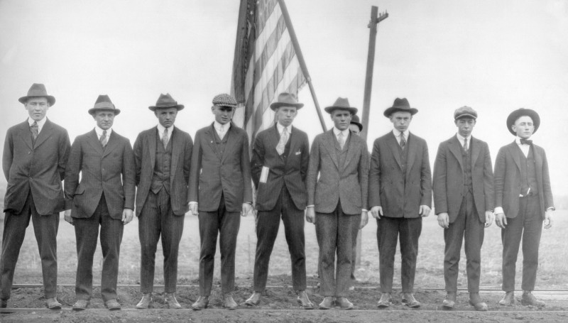 Gordon Petersen, Charles Petersen, Henry Wiedemann, Winiford Addison, Henry Grelck,
George Berg (failed physical), Henry Dethlefs, William Mergele, Carl Ryan
Gordon Petersen, Charles Petersen, Henry Wiedemann, Winiford Addison, Henry Grelck,
George Berg (failed physical), Henry Dethlefs, William Mergele, Carl RyanSome of these boys probably rode out of Manning on a Milwaukee passenger train to their boot camps.
In 2002, a fellow who is the great-nephew of Bessie Dunnick, inherited her 1917 MHS school scrapbook/diary. His name is Roger Markley and he scanned the pictures and some of the
booklet for me and e-mailed me the files. He had quite a few 1917 pix of Manning boys in their uniforms and other military pix). Unfortunately
they were VERY low resolution scans. I tried to get him to send me the scrapbook so I could scan everything, but for various reasons, he didn't think
I would be able to make any better scans so he wouldn't send it to me. I tried several years later to see if I could get him to send me that book to scan, but his e-mail address
was no longer working, and now I fear he may have passed away. He lived out in the eastern part of the US, but I forget exactly where.
My hopes are that he or
a relative of his will see my messages about that book on my web pages, or if deceased, that HOPEFULLY a descendant inherited it and KEPT it and will someday stumble on my website.
There were many amazing Manning pictures in that scrapbook - mostly identified but a few weren't which he didn't scan for me - I told him I had a number of old timers still
living who might be able to help, but not even that would encourage him to send me the book.
This is just ONE of hundreds of examples where people wouldn't/won't get me their old Manning scrapbooks to scan...many of which have since been thrown away.
Now let's take a look at this aerial photo that was taken in 1937. It is a cropped image out of a much larger view of Manning and this picture
once hung in the basement of the Legion Hall.
 #1 is the location of "Canary Island" which was formed when the Great Western RR came through Manning, and
rather than build dozens more bridges, they straightened the meandering Nishnabotna Creek in many places. As you can see from this picture, the "oxbow" became separated
from the creek when it was straightened by the Great Western grade.
#1 is the location of "Canary Island" which was formed when the Great Western RR came through Manning, and
rather than build dozens more bridges, they straightened the meandering Nishnabotna Creek in many places. As you can see from this picture, the "oxbow" became separated
from the creek when it was straightened by the Great Western grade.
It got its name from the Gold Finches that flocked in the reeds/weeds/grasses. Since this was
originally a wetland area, once the oxbow was separated from the creek, it filled up with water and was a good fishing hole and also where Manning folks came to swim.
At this point in time the bridge #2 was still there that crossed the Nishnabotna Creek and was discussed above in a previous section of this feature story...so the kids and adults could
walk over the bridge to get to Canary Island.
I've heard lots of stories about Canary Island (most I won't discuss now) but one stands out. A fellow by the name of Louie Hoffmann lived on a small acreage #8. We farmed
his small field in the mid-1960s. Anyway, Louie had a drinking problem and one fateful day he drowned in the creek.
I've gathered several accounts over the years
of that event. Louie was fishing and according to the stories I've put together, he fell in 3 times. The first time Alan & Doug Kusel fished Louie out.
Then Bruce Rutz (and possibly Tom Jensen) pulled Louie out of the water.
Unfortunately the 3rd time was not a charm for Louie. Marvin Gaer and Harold Reinke
came down to find Louie, since he had disappeared completely, but his fishing pole was still there.
Marv asked Bruce to wade in to see if he could find Louie's body...no luck.
Then Harold started tossing in the fishing hook, with the hopes to snag Louie's clothing, which he did, so they pulled his body out of the water.
I'm hoping to find Louie's obituary to see what it might say about the event that occurred sometime in the early 1960s.
The same time we were
cleaning up the field dad purchased that we now grow crops on.
Now the other major event occurred on Sunday morning, October 6, 1929.
I'm only going to mention the last name, because there are some grandchildren still living
and I want to tell this story as delicately as I can, but still tell it since it is a factual part of our history and sadly nothing new when it comes to suicides.
#6 is where this event took place.
Harold Reinke told me that he and some of his friends noticed someone walking across the trestle bridge carrying a rope...they thought nothing of it and went back to playing.
Then all of a sudden they heard the Great Western train (coming from the north) blowing the whistle continuously, so they ran to see what was
going on and then noticed a body hanging under the trestle and over the Great Western tracks...it was Mr. Flenker.
Other accounts I heard are that you could see the body hanging from the north end of Main Street as people were driving down it after church services...today if you drive
down Main Street, you can still see the area where the Great Western tracks once came under the trestle.
August 26, 2022

The crane is situated right over the location where the hanging occurred.
Now let's get back to locations that are not tragic like the previous 2 events discussed.
#7 on the aerial photo is the location of the Nishnabotna Creek.
#3 was the Northwestern Depot - part of it was relocated by August Mundt to his farm where it still stands today...and owned by his son - maybe someday
it can be moved back to the Trestle Park and restored.
#4 is the location of the Northwestern Stock Yards.
#5 shows the spur off the Northwestern that connected the Manning Mill (later MAC owned by Orland Fara)...originally this was the Doud Milling Company where they
made flour.
It was owned by Royal Doud - grandfather of Mamie (Doud) Eisenhower.
I tried hard to make sure that the brick building that was part of the Doud Milling Company was
saved when the MAC center was razed but, sadly, the Doud part was also torn down.

View of the Great Western RR - Canary Island on the left

Passenger train roaring into Manning, just north of the trestle
I could go on and on with more stories and history about this area, but I assume I've
already lost several readers with this much material to read.
"Water under the Bridge"This is not only an old clich� but literally billions of gallons of water have flooded through this
creek bottom since 1881.

Great Western tracks (left - west), Northwestern tracks (right),
Milwaukee tracks in the background.

1910 flood


Great Western stranded in another flood during early Manning history.

June 12, 1950

Manning Elevator Company - later J&S Feed Service

Photos taken by Joe Loucks


East side of the Airport Road - A Farmall and John Deere that should NOT have been left in the field.

The old city ball diamond
For those of you too young to remember these floods, the area developed
for flag football, soccer field, and lower ball diamond being used today will again be damaged by flood waters, probably not too far in the distant future...

Great Western bridge - 1950 spring snow melt flood.One of the reasons for severe flooding is because of all of the bridges supported by pilings in the
creek that caught buildings that washed in, trees and residue, and snow that drifted into the creeks and became "ice bergs" that jammed into the bridges...not only road bridges
but all of the railroad bridges that spanned the creek.
Marvin Gaer used dynamite to try to unjam some of these ice bergs in the 1960s and early 1970s.
 Great Western bridge just north of Third Street was jammed full of some wooden structure that was destroyed and washed in
by the flood waters.
Great Western bridge just north of Third Street was jammed full of some wooden structure that was destroyed and washed in
by the flood waters.
The decade of the 1990s was an extremely wet period, including the "500 year" flood in 1993.
It broke all previous flood records since 1881, by 2 feet.
Manning Livestock Auction - built by Robert Dappen, later purchased by Rexanne Struve

1993 August flood -
the red arrow shows the flood line at its maximum depth - around 4 feet up the walls.
Bob Genzen took this picture as I was unable to get into town during much of the flood.
Our lane and bottom road were under water.
Now we'll go back to the Milwaukee RR.

This area was used as a staging ground for many Manning parades - this one in 1925.

1941
The Northwestern tracks still there
was abandoned in 1937

The temptations were too great over the years, with many kids and even young adults deciding to climb the bridge.
I don't know what kind of trespassing laws existed back then but today if you got caught doing this, I'm sure the fines would be extensive.

Frances Horman and Frank Vollmer standing on one of the emergency outcroppings on the trestle.

Unknown man standing over the Nishnabotna Creek.

Unknown men
The extra steel and ties in between the 2 rails were designed to keep the train from flying over the edge if it would
derail...this extra precaution built in was only used on the trestle and bridge.

Erma & Enid Hays - twins and sister to Blanch Grelck
wife of Henry Grelck and grandmother of Sharon (Grimm) Williams

Derailment near the Milwaukee Depot

Unknown people - from the Iola (Taylor) Stammer collection

Milwaukee Road engine

1972

Harold Reinke's metal salvage building (left), Puck family shed in red, fuel barrels next, and finally the stock yards loading ramp.
The asphalt on the right side is where the Depot
loading/unloading was located.
You can see the original East Street bridge to the east that was replaced with the current bridge today.

Photo taken by Orval Fink, shortly before it was torn down.
William F. Ohde wanted to purchase the depot and move it, but Milwaukee refused and tore it down.
It is hard to tell anymore if spending all of this time to show off Manning and its history is worth my time, money, and effort.
I've always shown these feature stories to try to encourage more people to get me their old family/Manning pictures, collections, and albums to scan, but since I first set up my web
page in 1996, it has mostly been "crickets" for responses to help and share.
But from time to time I'll try to continue to post some more feature stories in the future, still with the hopes that these historical aspects
will encourage more people to come forward with their old Manning history...BEFORE their stuff is thrown away too.
I'm sure there are still lots of old pix out there in some Manning collection that I don't have and would be great to scan and then show in web page features like this one.
Someday those collections will all be gone and IF a future generation decides that history is important again, it will be too late.
Back to Dave Kusel's main page