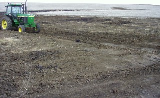
Less than 8 years ago we cleaned out this waterway. As you can see it has silted in almost 3 feet deep from tilled farm ground above. I'm just now getting down to the black soil with the dirt scraper.
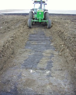
 The clay colored soil is topsoil washed in from a 15 acre watershed above this point. |
I estimate I hauled out 400 tons of topsoil in this area just to reshape the waterway.
|
The Black color is 11B soil which is 2.3 acres in size
The Yellow color is 9D2 soil type which is 7.7 acres & 300 feet long at the widest point. The Blue color is 9B2 soil type which is 4.7 acres & 130 feet long at the widest point. The longest distance from the discharge into the top of our waterway to the top of the hill is 900 feet. |
To the left is on the same farm but in a different location where only our No-Till crop land drains into the waterway.
This waterway is 900 feet long and is represented as the white line on the image below. A 20 acre watershed drains into this waterway but as you can see there are no gullies alongside & No silt. |
The Black color is 11B soil which is 3 acres in size
The Yellow color is 9D2 soil type which is 10.2 acres & 300 to 400 feet long at the widest point. The Blue color is 9B2 soil type which is 1.6 acres & 150 feet long at the widest point. The Green color is 9C2 soil type which is 5.5 acres in size The longest distance from the discharge at the bottom of the waterway to the top of the hill is 1330 feet. Here are the slope angles for the soil types.
|
The Water infiltration data at the link below partly explains why more soil erodes off a tilled field.
This page shows a water infiltration test that shows the dramatic difference in water infiltration on tilled soil versus No-Tilled soil.